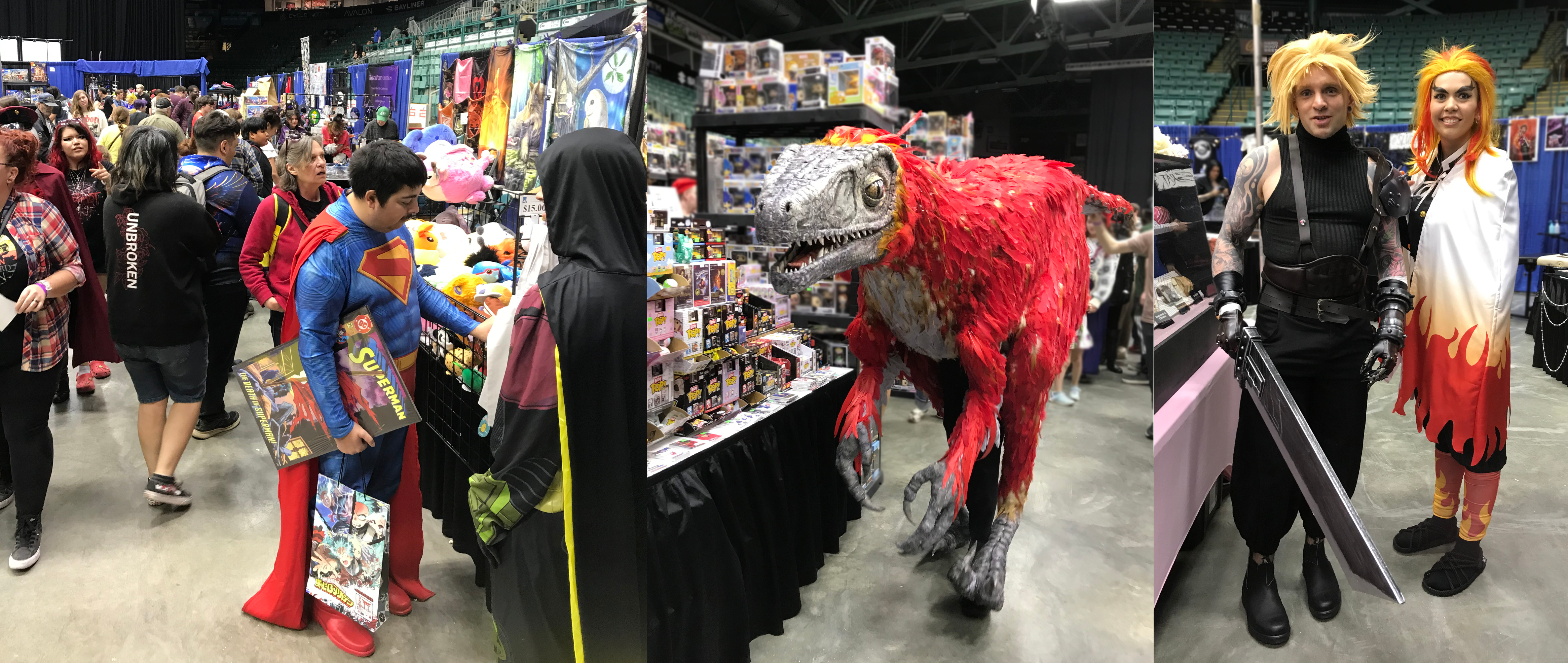
Various ‘characters’ ply through the dense crowds of Northern Fan Con (photos by Nina Munteanu)
.
Last weekend I drove north to Prince George to join publisher/writer Lynda Williams and her team at Reality Skimming Press at the Northern Fan Convention. Held at the CN Centre, the con and trade show was very well attended, with booths that held anything from realistic light sabers to anime figurines and collectible cards–and so much more. The con also featured shows with media celebrities, cosplay, workshops, and–of course–the obligatory costume contest.
.
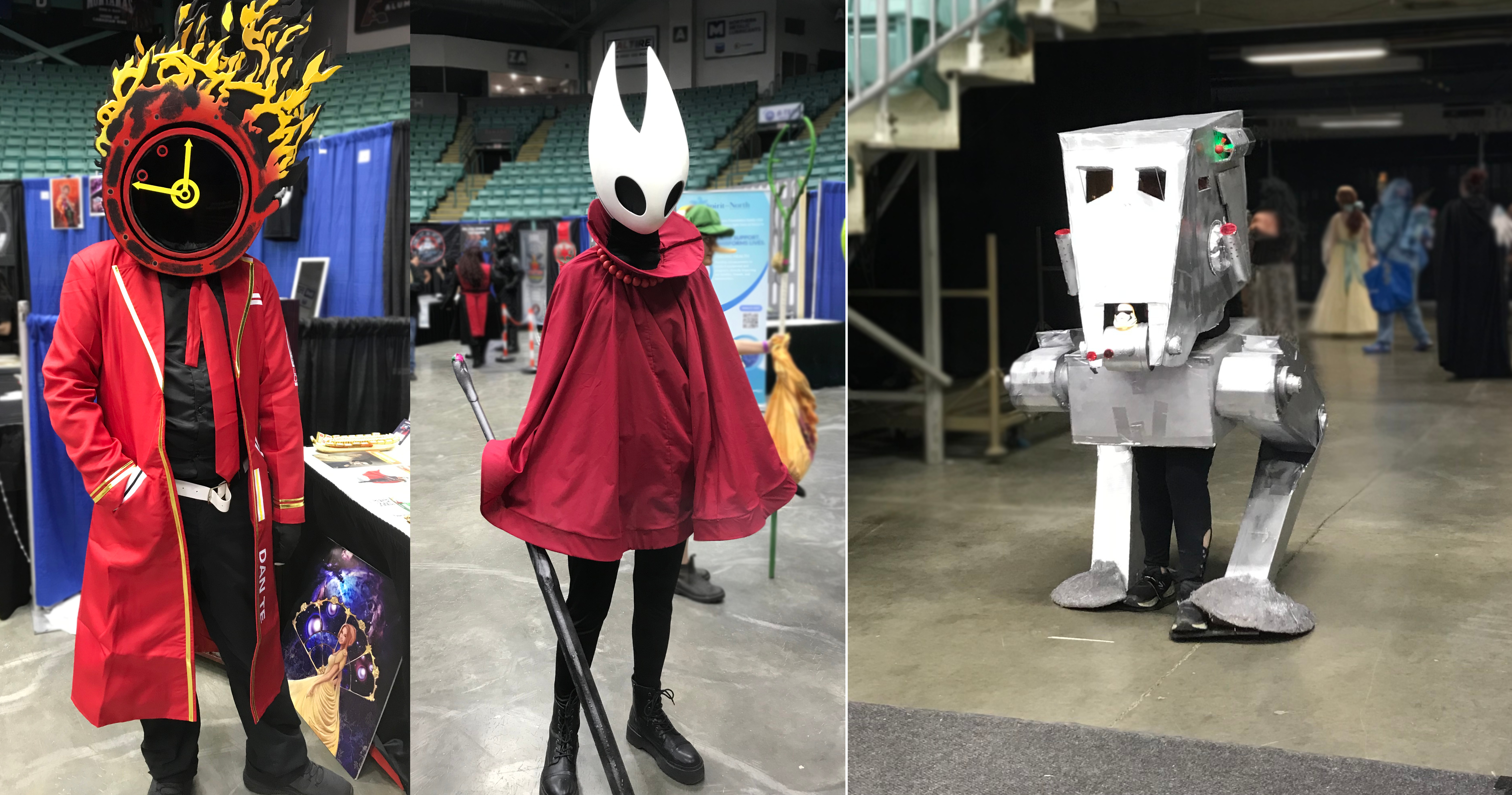
‘Dante’ and ‘Hornet’ join an AT ST making rounds at Northern Fan Con(photos by Nina Munteanu)
.
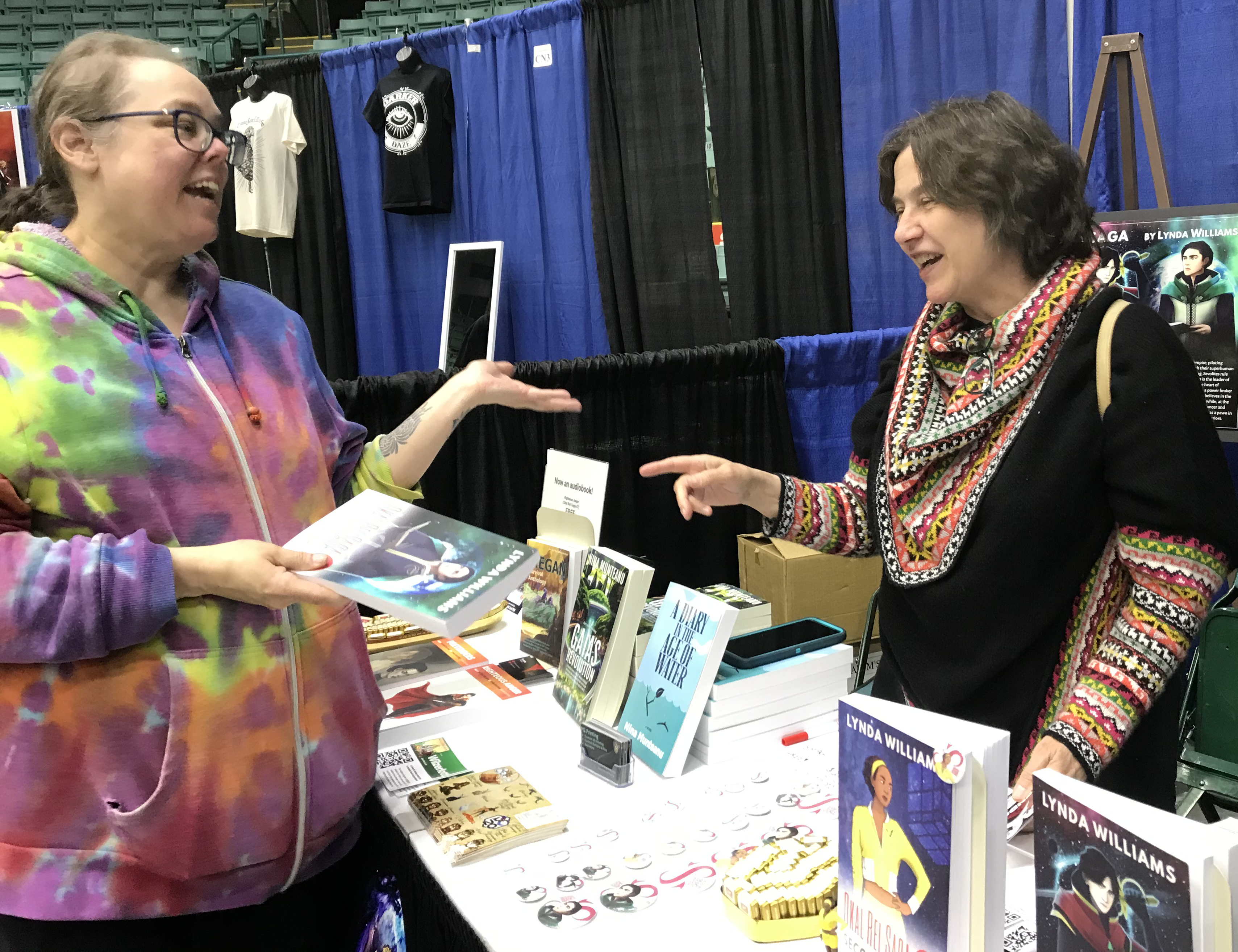
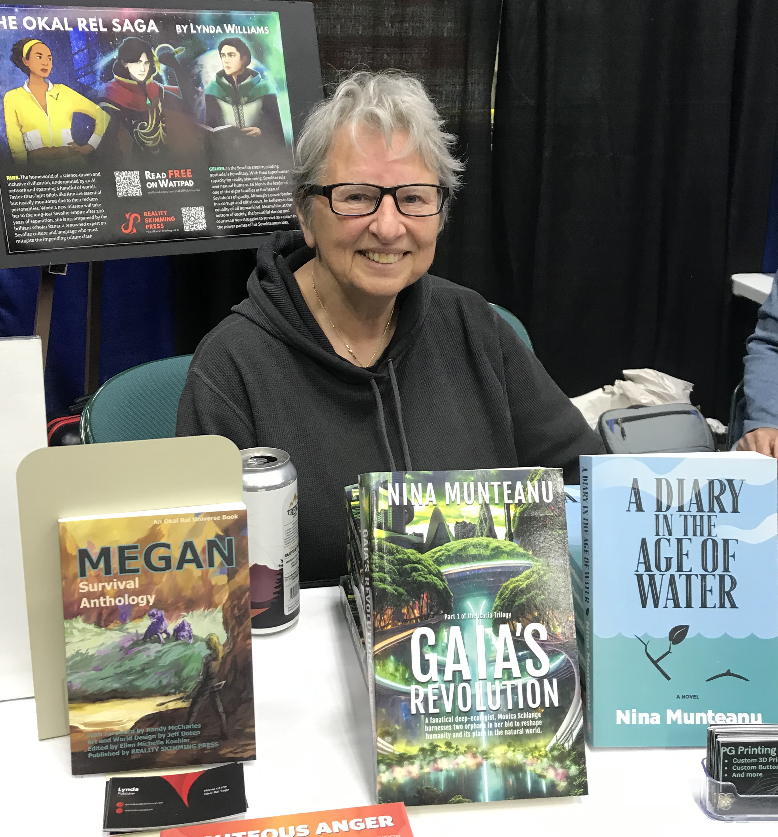
I helped man the publisher’s table where we were selling books in the Okal Rel series; I also sold out on my two latest novels A Diary in the Age of Water and Gaia’s Revolution.
.
Lynda Williams with a book buyer at Northern Fan Con (photo by Nina Munteanu)
Nina Munteanu selling out her books at Northern Fan Con
.
Oh! And I got to play with a Stars Wars storm trooper and tai fighter. Not bad for one weekend!
.
Nina with several Star Wars friends
.
.
Nina Munteanu is a Canadian ecologist / limnologist and novelist. She is co-editor of Europa SF and currently teaches writing courses at George Brown College and the University of Toronto. For the lates on her books, visit www.ninamunteanu.ca. Nina’s bilingual “La natura dell’acqua / The Way of Water” was published by Mincione Edizioni in Rome. Her non-fiction book “Water Is…” by Pixl Press (Vancouver) was selected by Margaret Atwood in the New York Times ‘Year in Reading’ and was chosen as the 2017 Summer Read by Water Canada. Her novel “A Diary in the Age of Water” was released by Inanna Publications (Toronto) in June 2020.You can read her just released eco-fiction thriller Gaia’s Revolution by Dragon Moon Press.
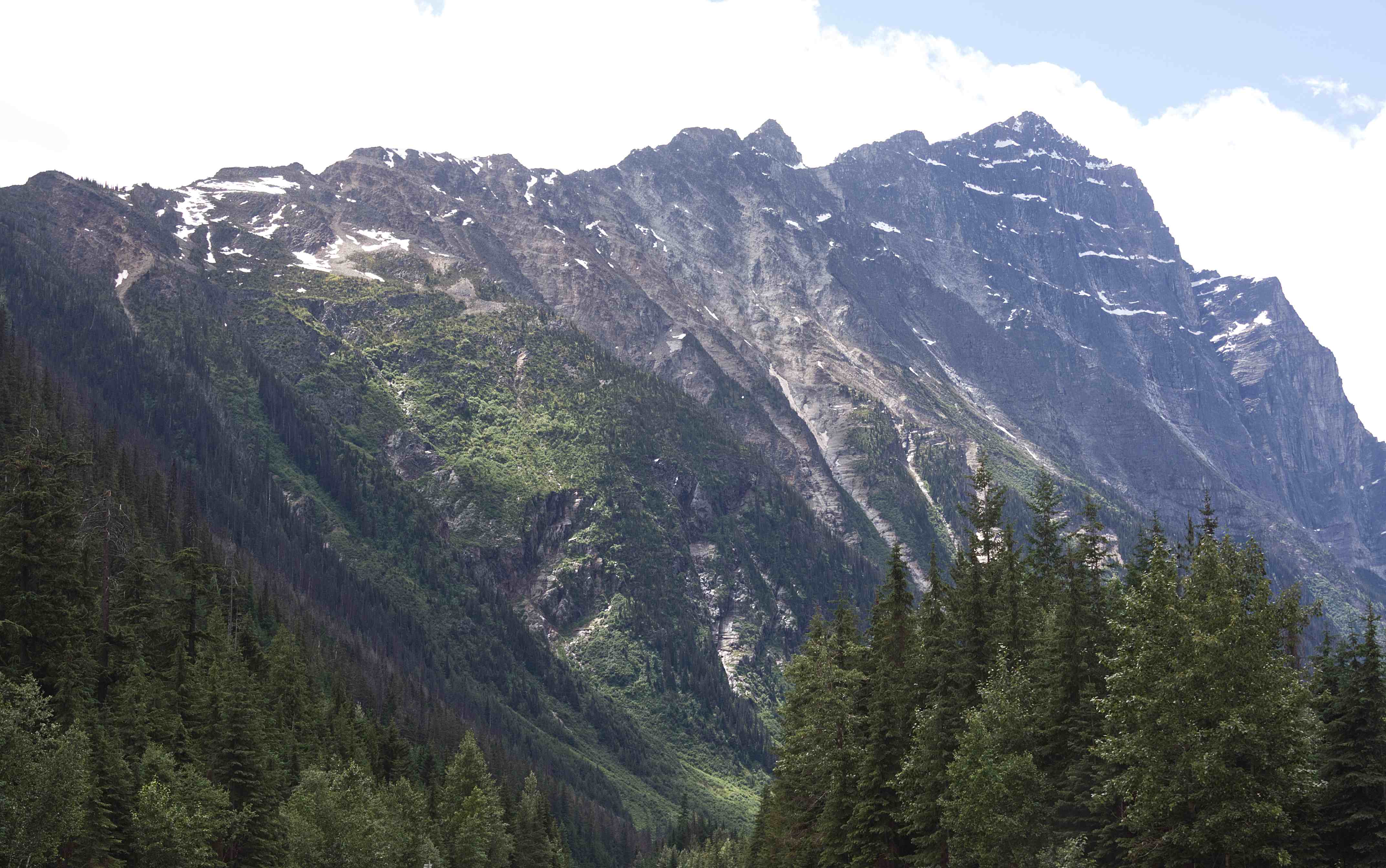
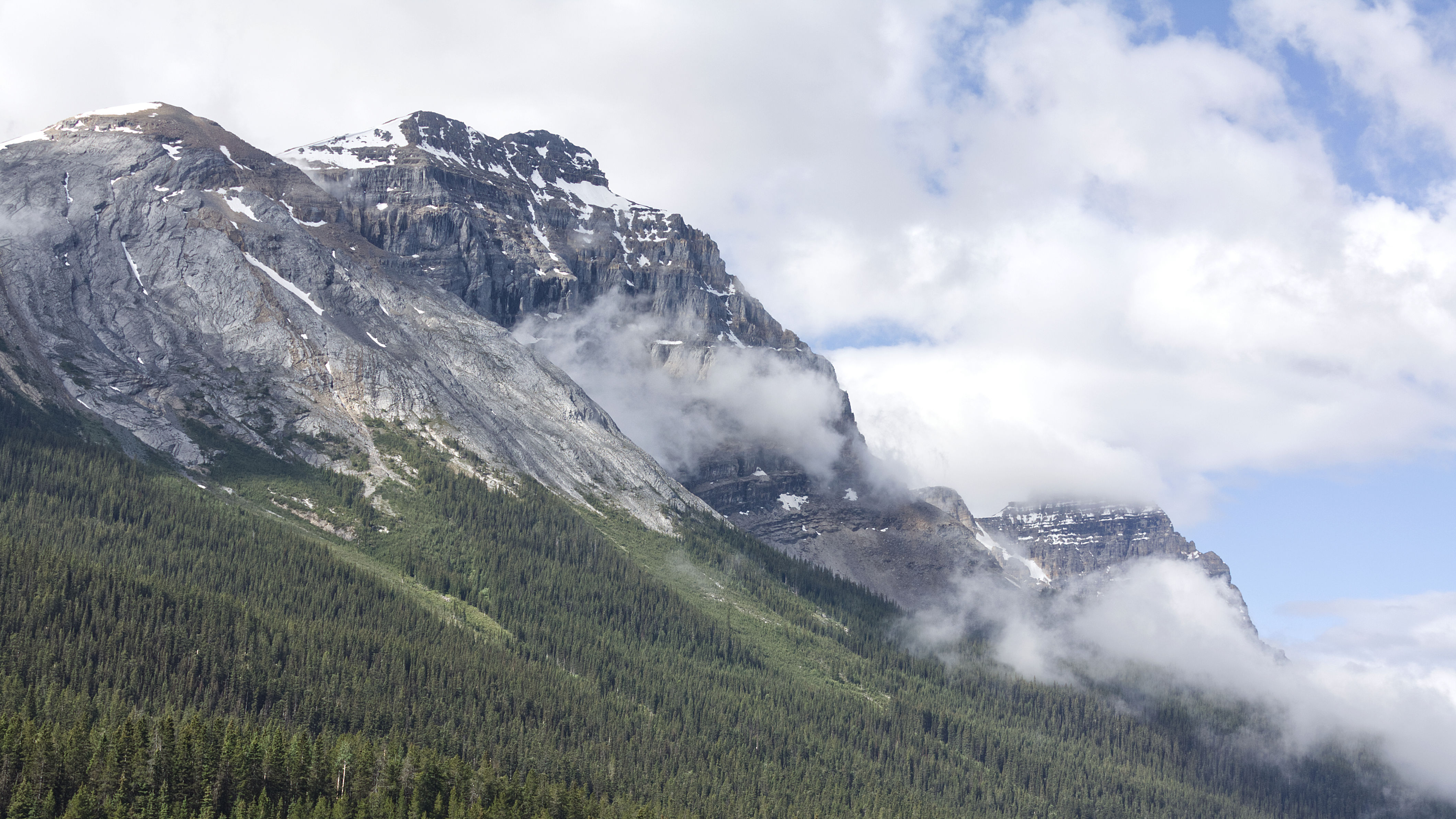
From the rolling Prairies I ascended up the foothills of the Rocky Mountains in Alberta. As I neared the mountains, they seemed to cut the sky with jagged peaks of steely grey. Rugged and unabashedly wild, they teased my spirits into flight.
Rocky Mountains, Alberta (photo by Nina Munteanu)
Canadian Rockies, AB (photo by Nina Munteanu)
.
The Rockies are such a wonder! I found myself thinking—well, wishing—that I had a geologist sitting in the passenger seat (instead of my companions Toulouse, Mouse and a car full of plants), telling me all about these stately mountains and their formations. All that folding, thrusting, scraping and eroding! So fascinating!
.
Rockies west of Banff, AB (photo by Nina Munteanu)
.
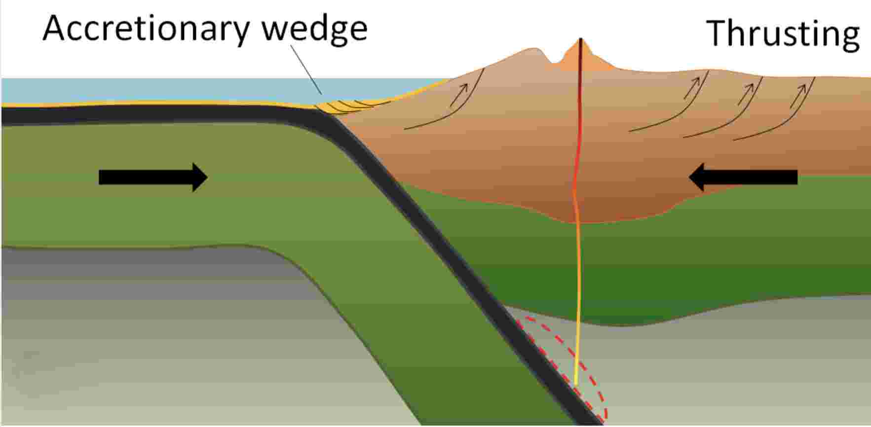
I did some research into The Canadian Rocky Mountains and discovered that they were formed through a combination of subduction and thrust faulting with an oceanic plate subducting beneath the North American plate.
.
Sketch showing subduction of ocean plate beneath the North American plate with accompanying accretionary wedge and thrusting action (image by Earle and Panchuk)
.
The Canadian Rocky Mountains were originally part of an ancient shallow sea half a billion years ago and formed from pieces of continental crust over a billion years old during an intense period of plate tectonic activity. Their jagged peaks of mostly sedimentary limestone (originally part of the continental shelf) and shale (originally part of the deeper ocean waters) belonged to an ancient sea floor; during the Paleozoic Era (~5-2 hundred million years ago), western North America lay beneath a shallow sea, depositing kilometers of limestone and dolomite.
.
Rocky Mountains near Canmore, AB (photo by Nina Munteanu)
.
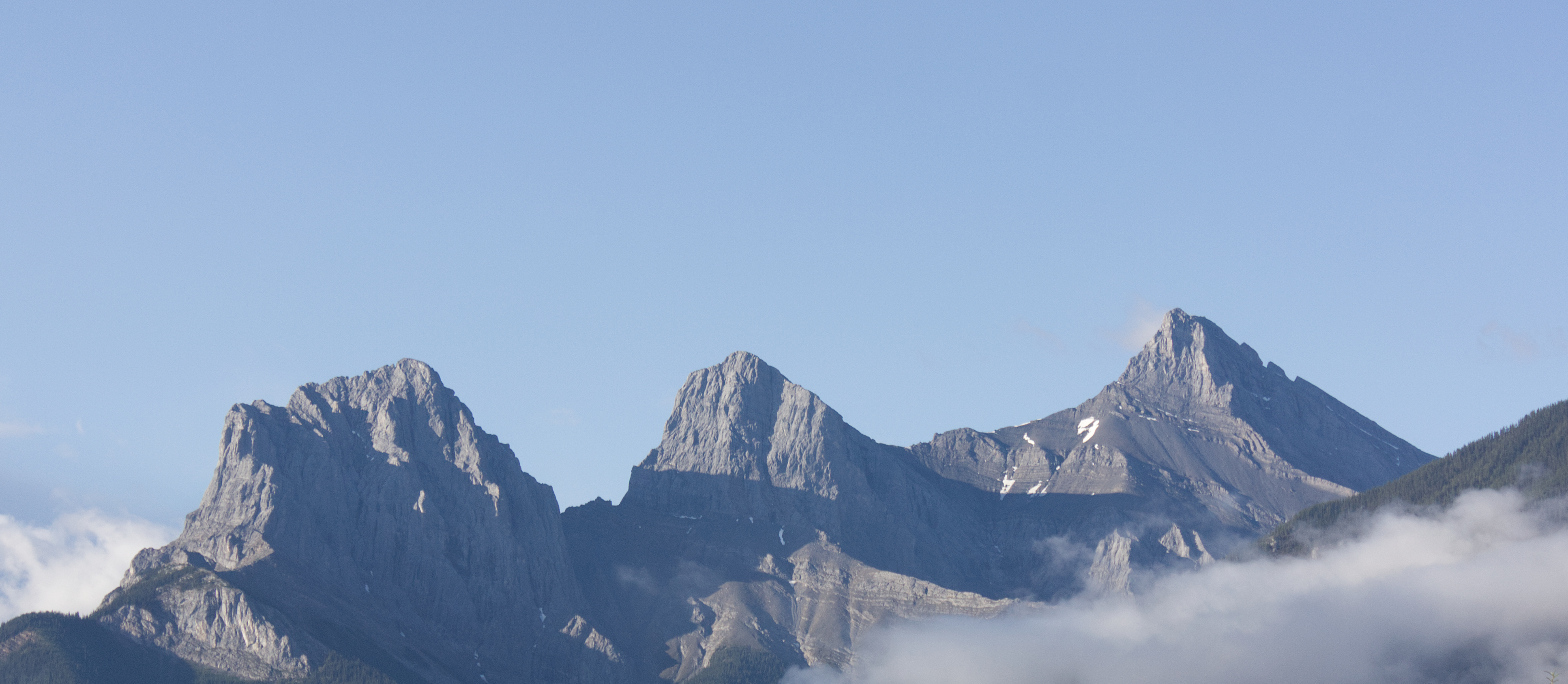
The current Canadian Rocky Mountains were raised by the Cordilleran Orogeny, a process of mountain-building when tectonic plates started colliding ~ 200 million years ago during much of the Mesozoic Era, which extends over 187 million years from the beginning of the Triassic (252 Ma) to the end of the Cretaceous (65 Ma). This era, I’m told, was a particularly important period for the geology of western Canada. During the plate and land mass collisions, ancient seabed layers were scraped, folded and thrust upwards (through a process called thrust faulting). As plates converged, entire sheets of sedimentary rock were slowly pushed on top of other sheets, creating a situation where older rocks lie on top of younger ones.
.
Castle Mountain overlooks the Bow River, Canadian Rockies, AB (photo by Nina Munteanu)
.
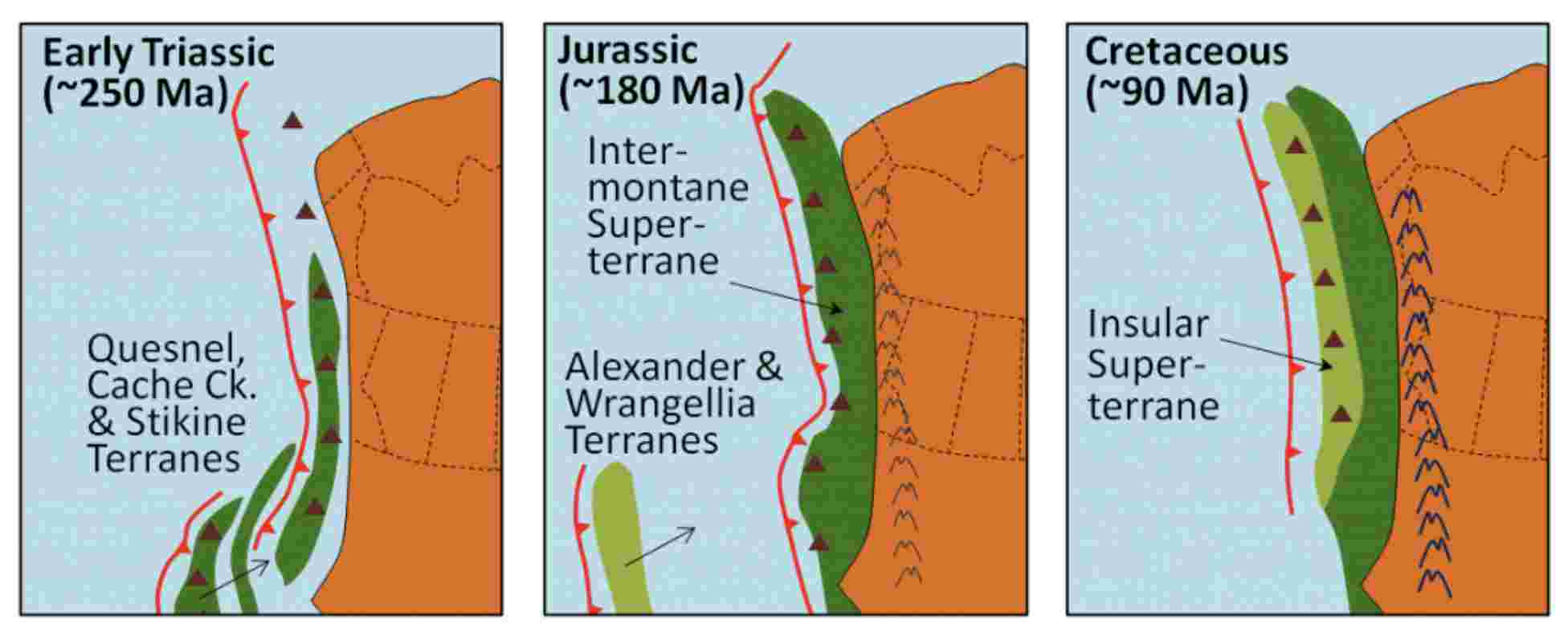
According to Earle and Panchuk, several continental collisions occurred along the west coast over the Mesozoic, resulting in the formation of the Rocky Mountains and the accretion (addition) of much of British Columbia’s land mass. Starting in the early Triassic (~250 Ma) through to the Cretaceous Period (~90 Ma), continued subduction sent several continental terranes (land masses) colliding into and accreting to the western edge of North America. The Quesnel, Cache Creek, and Stikine Terranes formed the Intermontane Superterrane, which now forms BC’s interior plateau between the Rockies and the Coast Range. A hundred million years later, during the Jurassic Period, a pair of terranes—Alexander and Wrangellia—collided with the west coast to form most of Vancouver Island and Haida Gwaii as well as part of Alaska. During the Cenozoic Era, more terranes accreted with the western edge of North America.
.
Model of the accretion of the Superterranes to the west coast of North America during the Mesozoic Era; red toothed lines=subduction zones; dark red triangles=volcanoes (images by Earle and Panchuk, 2019)
.
In the Jurassic Period, the Intermontane Superterrane acted like a giant bulldozer, pushing, folding, and thrusting the existing Proterozoic and Paleozoic west coast sediments eastward and upward to form the Rocky Mountains. The same process continued into the Cretaceous as the Insular Superterrane collided with North America and pushed the Intermontane Superterrane farther east.
.
Cross-section of the accretion of the Intermontane Superterrane to the west coast of North America in Jurassic and early Cretaceous, with resulting compression folding and thrusting of sedimentary rocks. Late Cretaceous Insular Superterrane further pushed against the Intermontane Superterrane to create massive folding and thrusting (image from Earle and Panchuk, 2019)
.
Canadian geologist/author Ben Gadd explains the Canadian Rocky Mountain building through the metaphor of a rug being pushed on a hardwood floor: the rug bunches up and forms wrinkles (mountains). In Canada, the subduction (downward movement) of an oceanic tectonic plate and the terranes (slabs of land) smashing into the continent are the feet pushing the rug, the ancestral rocks are the rug, and the Canadian Shield in the middle of the continent is the hardwood floor. The Rockies, writes Gadd, were like Tibet: a high plateau, 6,000 metres above sea level. Then, in the last 60 million years, glaciers—creeping forward at 50 feet per year—stripped away the high rocks, revealing the ancestral rocks beneath and carving out steep U-shaped valleys to form the current landscape of the Rockies: jagged peaks of soft sedimentary limestone and shale overlooking steep gorges and valleys. You can watch an excellent video of the 200-million-year formation of the Rocky Mountains by Spark.
.
Castle Mountain, Canadian Rockies, AB (photo by Nina Munteanu)
Rockies west of Lake Louise, Alberta (photo by Nina Munteanu)
.
When I stopped in Canmore, Alberta, for the night, I found all the hotels solidly booked, except for a few very expensive rooms in high end hotels. It was the weekend of the Calgary Stampede and the crowds had spilled out this far, I was told. I also acknowledged that I was plum in the middle of tourist season too. But I was dead tired and it would be dark soon; so, I bit the bullet and booked an expensive room in an expensive hotel. I recalled that I was repeating my mother’s trip across Canada to settle in Victoria many years ago; she’d also driven through here in her old Datsun, brim with plants, like my Benny, and stopped in Canmore for the night. Only, she found very reasonable accommodations when she came through over four decades ago. Canmore is located in the front ranges of the Rockies, with a wonderful view of the Three Sisters and Ha Ling Peak from my hotel room.
.
The Three Sisters, Canmore, AB (photo by Nina Munteanu)
.
Temple Mountain, west of Lake Louise, Alberta (photo by NIna Munteanu)
.
I gave Banff and Lake Louise a miss and opted for a breakfast at some remote viewpoint after crossing the border into British Columbia. As I ate my cereal from the tailgate of my car, I felt a strange but lovely warm joy spread through me like a deep soothing balm.
I was home…
.
Faeder Lake, Yoho National Park, BC (photo by Nina Munteanu)
.
I stopped at Faeder Lake, on the western side of Yoho National Park, with a view of the Ottertail Range and Mount Vaux. Faeder Lake’s clear tourquise water—a result of fine particles of rock dust called glacial flour—enticed me for a swim.
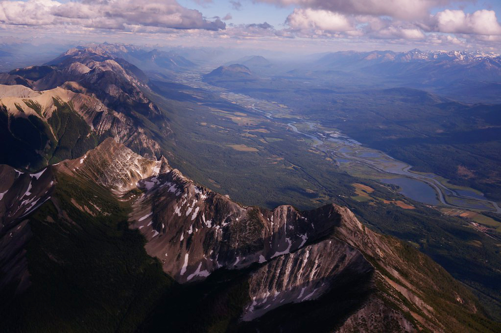
I stopped briefly for lunch in Golden in the Rocky Mountain Trench. The Rocky Mountain Trench is a long and deep valley walled by sedimentary, volcanic and igneous rock that extends some 1,500 km north south, spanning from Montana through British Columbia. The Trench is sometimes referred to as the “Valley of a Thousand Peaks” because of the towering mountain ranges on either side: the Rocky Mountains to the east and the Columbia, Omineca and Cassiar mountains to the west.
.
Rocky Mountain Trench near Golden, BC
.
The Trench is a large fault—a crack in the Earth’s crust—and bordered along much of its length by smaller faults. Major structural features resulted from the shifting and thrusting of tectonic plates of the crust during the early Cenozoic Era (65 million years ago) during mountain formation discussed above. The ridges of fractured crust pulled apart and the land in between dropped, creating the floor of the Trench. Major rivers that flow through the trench include the Fraser, Liard, Peace and Columbia rivers.
.
The Rocky Mountain Trench features in two of my books: A Diary in the Age of Water (Inanna Publications) and upcoming novel Thalweg. In both novels, which take place in the near future, the trench has been flooded to create a giant inland sea to serve as water reservoir and hydropower to the USA. You can read an excerpt in my article “A Diary in the Age of Water: The Rocky Mountain Trench Inland Sea.” The article also talks about the original 1960s NAWAPA plan by Parsons Engineering to flood the trench to service dry sections of the US by diverting and storing massive amounts of Canadian water. Proponents are still talking about it!
.
Mount Macdonald, Rogers Pass, BC (photo by Nina Munteanu)
.
I entered Glacier National Park, driving through several snow & avalanche sheds at Rogers Pass, in the heart of the Selkirk Range of the Columbia Mountains. This part of the drive was spectacular as mountains towered close and steep above me like sky scrapers, fanning out as the bright green vegetation crept resolutely up their scree slopes.
.
Selkirk Mountains and Mount Macdonald in Roger’s Pass; Google location (image by Google Maps)
.
Selkirk Range at Rogers Pass, BC (photos by Nina Munteanu)
The highway followed the Illecillewaet River as it wound southwest to Arrow Lake from it’s the glaciers east. I soon reached Revelstoke National Park and stopped at the Giant Cedars Boardwalk Trail, located about 30 km east of Revelstoke, between the Monashee Mountains, west, and the Selkirk Range, east.
.
Boardwalk through ferns, devils club and giant cedars, Giant Cedar Boardwalk, Revelstoke National Park, BC (photo by Nina Munteanu)
.
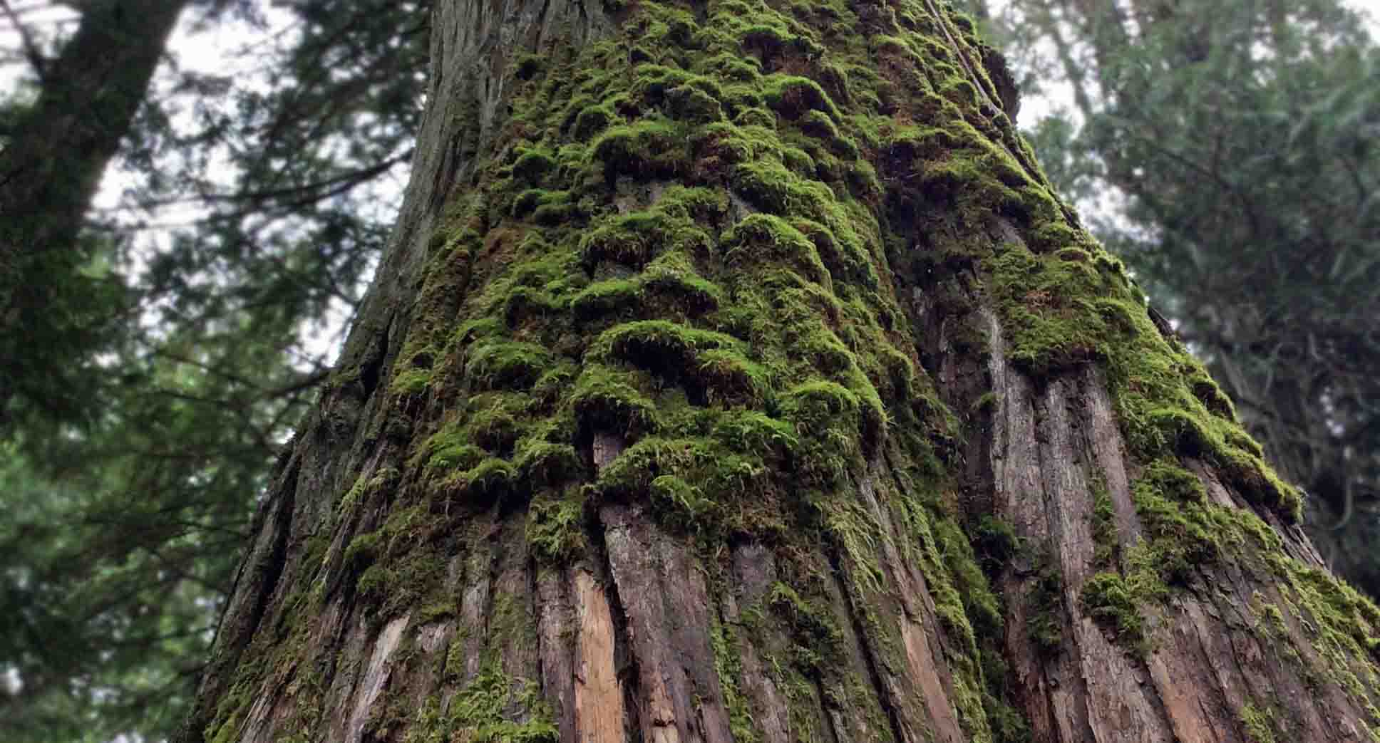
The Giant Cedars Boardwalk Park is a rare inland temperate rainforest ecosystem, receiving significant precipitation from Pacific weather systems that rise over the Columbia Mountains and dump here. It is a lush and humid old-growth forest with rich diversity of plant and animal life that resembles a coastal rainforest. Dominated by Western Red Cedars and Western Hemlocks—with some Douglas fir, paper birch and Bigleaf maple—the forest floor is a rich understory of salal, devil’s club, several berry shrubs and a diversity of ferns—oak fern, sword fern, and licorice fern. All was covered with a dense carpet of mosses, lichens, liverworts and fungi.
.
Above: moss-covered Red Cedar; Below: Devil’s club; Giant Cedar Boardwalk Trail, Revelstoke National Park, BC (photos by Nina Munteanu)
.
I followed the boardwalk through a cathedral of towering trees, among ancient cedars, whose fibrous, thick trunks loomed high to pierce the sky. Some are over 500 years old. I found that one large cedar trunk beside the boardwalk was ‘smooth from loving’ as I leaned against it and stroked its bark, no longer fibrous but burnished smooth and shiny.
.
Nina leans against a giant red cedar, fibrous bark smoothed from copious stroking of hands, Giant Cedar Boardwalk Park, BC (photo by Anne Voute)
.
I reached Revelstoke just after 6 pm and, to celebrate, I booked a room at the Regent Hotel. After a walk through the ski resort town, alive with young tourists, I returned to the hotel restaurant, I treated myself to a celebratory salmon dinner with garlic mashed potatoes and mixed veggies. I even I had a dessert—Tiramisu with a cup of tea—and went to bed sated, happy and tired. As soon as my head hit the pillow, I was in dreamland.
.
Revelstoke and the Regent Hotel; my celebratory meal there (photos by Nina Munteanu)
.
Chaparral near Merritt, BC (photo by Nina Munteanu)
Two types of sage brush near Merritt, BC (photo by Nina Munteanu)
.
The next day, I descended southwest from the Selkirk Range, passing through Kamloops and then arriving at Merritt, in the heart of the Nicola Valley, an area of dry forests, grasslands, sagebrush, alpine meadows, and wetlands. This was range country, dry, golden and rolling with the peppery scent of sage. The most visible and dominant vegetation included big sage (Artemisia tridentata) and bluebunch wheatgrass (Pseudoroegneria spicata) with the odd Ponderosa Pine (Pinus ponderosa) dotting the dry landscape.
.
Sagebrush country at Merritt, BC (photo by NIna Munteanu)
Sagebrush country near Merritt, BC (photo by Nina Munteanu)
.
From there, I drove south along the Coquihalla Highway in the Cascades Range to Hope, where I treated myself to an ice cream cone and ate it overlooking the mighty Fraser River. I followed the Fraser west to Vancouver, where it empties into the Pacific Ocean.
My last stop before reaching my good friend’s place in Ladner (where I would stay until I found my own place) was the Four Winds Brewery on Tilbury Road, where I bought a case of beer for the pizza we would share once I got there.
Earle, Steven and Karla Panchuk. 2019. “Physical Geology”, 2nd edition: Chapter 21: Geological History of Western Canada, 21.4, Western Canada during the Mesozoic.” BCcampus. OpenTextBC/Physical Geology
Munteanu, Nina. 2020. “A Diary in the Age of Water.” Inanna Publications, Toronto. 328 pp.
.
Nina Munteanu is a Canadian ecologist / limnologist and novelist. She is co-editor of Europa SF and currently teaches writing courses at George Brown College and the University of Toronto. Visit www.ninamunteanu.ca for the latest on her books. Nina’s bilingual “La natura dell’acqua / The Way of Water” was published by Mincione Edizioni in Rome. Her non-fiction book “Water Is…” by Pixl Press (Vancouver) was selected by Margaret Atwood in the New York Times ‘Year in Reading’ and was chosen as the 2017 Summer Read by Water Canada. Her novel “A Diary in the Age of Water” was released by Inanna Publications (Toronto) in June 2020.
Lynda Williams, author of science fiction series The Okal Rel Saga and publisher of Reality Skimming Press has just pulled together a writers group in Prince George, B.C., for writers to connect with other writers and share feedback on fiction and nonfiction.
Meetings will start March 20 and continue every other Thursday following from 7-9 pm at the Live Well Prince George Society.
All levels of experience are welcome. There is a $2 donation per drop in or $10 annual membership.
You walk toward English Bay to the nearest Hydrogenase Hub, where you are meeting with your team to discuss the presentation.
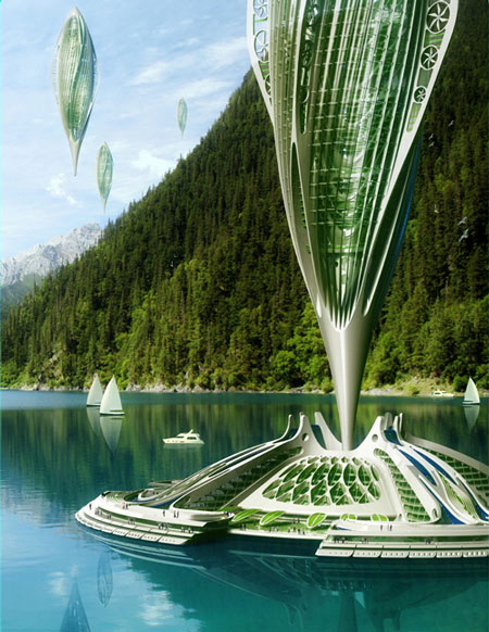
The hub is a floating algal farm. The farm and the elongated seed-shaped airship docked at its centre both produce biofuel—essentially hydrogen—from the microorganism Chlamydomonas reinhardtii. Your mom, a former environmental consultant and algal scientist—now she writes science fiction—explained to you that this unicellular organism has both plant and animal properties; it carries out photosynthesis but is also heterotrophic (able to use organic carbon to grow) and will in the absence of oxygen produce gaseous hydrogen and metabolites such as formate and ethanol through hydrogenase enzymes. Chlamydomonas reinhardtii was first discovered as a clean source of hydrogen back in 1939 by German scientist Hans Gaffron at the University of Chicago (ironically the same year Germany invaded Poland). Gaffron called it “photosynthetic hydrogen production by algae”; and today it is a process that produces electricity and biofuel with zero emissions.
The algae farm recycles CO2for the bio-hydrogen airship you will be boarding after your meeting in the hub. You enter the airy station, whose honeycomb circular design resembles a stylized lily pad and glance up through the high nano-glass ceiling toward the elongated seed-shaped transport rising ten stories above you. The sun glances off the diaphanous double helix frame that resembles a freshwater spirogyra. The hub you’re standing in is a floating algae farm with solar cells on top and hydro-turbines below to capture tidal energy. The algae farm recycles CO2 for the bio-hydrogen airship you will be boarding after your meeting in the hub. You enter the airy station, whose honeycomb circular design resembles a stylized lily pad and glance up through the high nano-glass ceiling toward the elongated seed-shaped transport rising ten stories above you.
The sun glances off the diaphanous double helix frame that resembles a freshwater spirogyra. The hub you’re standing in is a floating algae farm with solar cells on top and hydro-turbines below to capture tidal energy.
The concept is the “subversive architecture” of Belgian architect Vincent Callebaut and inspired by the principles of biomimicry, coined by Janine Benyus in 2002 in her book “Biomimicry: Innovation Inspired by Nature”. Callebaut conceived Hydrogenase in 2010 as a 100% self-sufficient and zero-emission transport system using algae. He claimed that a hectare of seaweeds could produce 120 times more biofuel than a hectare of colza, soya or sunflower without consuming land needed for crops or forests. He called Hydrogenase a true miniature biochemical power station. Able to absorb CO2 as the main nutrient through photosynthesis the algae, under anaerobic conditions, produce hydrogen in vitro or in bioreactors.
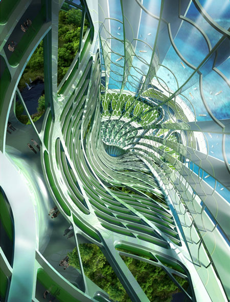
You swipe your PAL over the ticket booth sensor and the optional ticket-brochure pops out. You take it and read the specs between glances at the tall vessel loading in the dock of the hub. It’s really like a vertical dirigible, you think, studying the seed-shaped airship with self-cleaning “intelligent” nanostructured glass—inspired by the lotus leaf that doesn’t get wet. The semi-rigid unpressurised airship stretches vertically around an arborescent spine that twists like chloroplast ribbons 400 meters high and 180 meters in diameter.
You read that each Hydrogenase airship is covered with flexible inflatable photovoltaic cells and twenty wind turbines to maneuver and collect energy. The interior spaces provide room for housing, offices, scientific laboratories, and entertainment, and a series of vegetable gardens that provide a source of food while recycling waste.
You read that this self-sufficient organic transport flies about 2000 meters high at about 175 km/hr (twice the speed of a conventional ship). Given its ease in negotiating airspace and its ability to land and take off from virtually any location, the Hydrogenase is used by many groups in various capacities. Your friend Michael who teaches at the University of Victoria uses one as a mobile research station in his studies along the coast of northern British Columbia.
The vessel is made of “intelligent layers” and “self-separable ceramics”. Its bionic coating draws inspiration from sharkskin that is self-cleaning and flow-efficient.
Hydrogenase concept with algal farm pods and air ships
You head down the spiral staircase to the third subsea level toward the meeting room you booked earlier on your PAL. The view is spectacular from here through the nano-glass panes. Rays of shimmering light stream through a gently swaying forest of kelp. You glimpse the sun-glinted flickering of hundreds of anchovies as they school through the kelp. This floating farm is an organic purifying station of four carbon wells where the algae recycle the carbonated waste brought by the airships and, in turn, feed the airship with biohydrogen. It’s the new “gas station”, you reflect with a smile.
After your meeting with staff, you and three others of your team board the airship and settle in one of the skyview chambers. The journey is relaxing, like the BC Ferry used to be, but without the pungent smell and pollution of conventional motorized sea vessels. It’s a quiet and relaxing trip with a spectacular view of the Gulf Islands. Your team strategizes your presentation over a light lunch and Matcha lattes.
Vincent Callebaut’s Hydrogenase
The PA system sounds and a woman’s voice informs you that the ship will be making an emergency landing on Saturna Island to rescue two hikers injured at East Point. This will only add twenty minutes to the trip, the woman assures you. You don’t mind and recall the disclaimer at the bottom of the ticket. Given the ability of this airship to take off and accurately land virtually anywhere, all Hydrogenases are by law mandated to be on standby for rescue missions in rough terrain.
You pull out the ticket and read again: The Hydrogenase is affiliated with the International Red Cross and BC Coastguard. The Hydrogenase must by law respond to any distress call at sea or rough terrain associated with coastal waters. Because of this service, we cannot guarantee a timely schedule.
You recall how Hydrogenases were deployed in the last hurricane disaster off the coast of Florida last year, saving countless people trapped in the flooding that accompanied the storm. The International Red Cross uses them as flying hospitals.
Bernard frets over the time delay. He is concerned about the lack of preparation and set up time once you get into Victoria. You assuage him gently. The best preparation is sincerity, you tell him. The landscape architect Thomas Woltz, whose work you highly respect, saw himself as someone who embraces the complexity of modern life while seeking meaning and narrative in both natural and human-made environments.
“We’re storytellers,” you tell Andre. Invoking metaphor through design. “They know we’re coming and they know we’re helping someone; they’ll wait for our story. And it’s all about harmony.”
The lines of Henry David Thoreau come to you: Man’s life must be of equal simplicity and sincerity with nature, and his actions harmonize with her grandeur and beauty.
Then you point your PAL at the ServiceBot and order three more lattes. You lean back in your bamboo fabric chair and cross your legs over the leg rest.
It’s a brave new world.
Pine forest in Jackson Creek Park, ON (photo and dry brush rendition by Nina Munteanu)
Nina Munteanu is a Canadian ecologist / limnologist and novelist. She is co-editor of Europa SF and currently teaches writing courses at George Brown College and the University of Toronto. Visit www.ninamunteanu.ca for the latest on her books. Nina’s bilingual “La natura dell’acqua / The Way of Water” was published by Mincione Edizioni in Rome. Her non-fiction book “Water Is…” by Pixl Press(Vancouver) was selected by Margaret Atwood in the New York Times‘Year in Reading’ and was chosen as the 2017 Summer Read by Water Canada. Her novel “A Diary in the Age of Water” was released by Inanna Publications (Toronto) in June 2020.
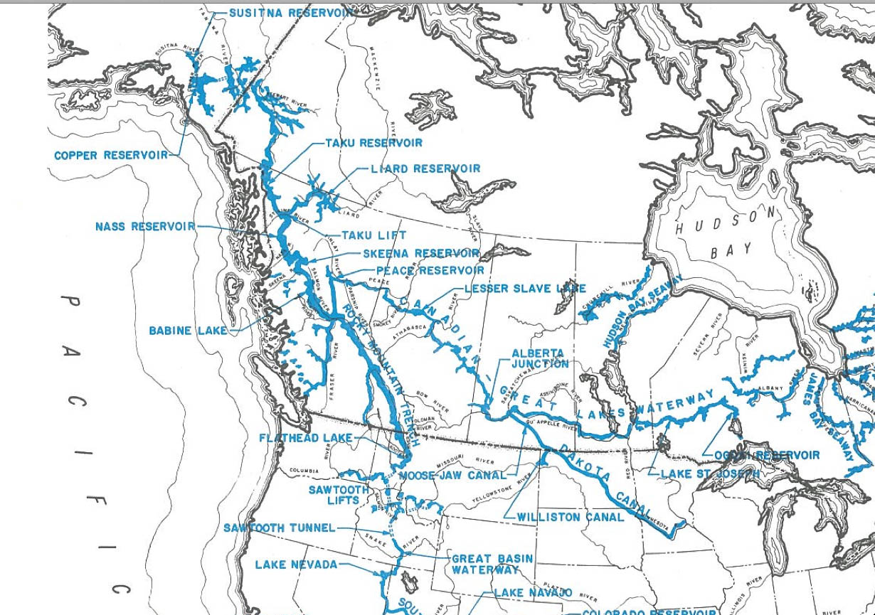
In my novel “A Diary in the Age of Water” (Inanna Publications) the diarist writes about the huge 800-km reservoir complex built in the late 2020s in the Rocky Mountain Trench to rehydrate the United States. Of course, it’s science fiction, but it was based on real plans that went all the way to Congress in the 1960s.
Snaking along the length of the Rocky Mountain Trench, the reservoir promised to submerge numerous British Columbia towns such as Dunster, McBride and Valemount and pose an existential threat to northern communities of BC and Alaska.
The Trench
The Rocky Mountain Trench is a long and deep valley walled by sedimentary, volcanic and igneous rock that extends about 1,500 km from Flathead Lake and the ‘banana but’ of the Bitterroot Valley of western Montana through British Columbia to the Liard Plain just south of the Yukon Territory. Blanketed mostly by white and black spruce, subalpine fir and lodgepole pine, the northern trench stretches 3–20 km wide to accommodate the major river systems that snake along its mostly flat floor. This rich ecosystem is home to bears, caribou, moose and wolves. To the south, where the valley meanders more at lower elevation, the forest opens up and gives way to grasslands, marsh and farmland. The Trench is sometimes referred to as the “Valley of a Thousand Peaks” because of the towering mountain ranges on either side: the Rocky Mountains to the east and the Columbia, Omineca and Cassiar mountains to the west.
The Trench is a large fault—a crack in the Earth’s crust—and bordered along much of its length by smaller faults. Major structural features resulted from the shifting and thrusting of tectonic plates of the crust during the early Cenozoic Era, some 65 million years ago to form mountains. The ridges of fractured crust then pulled apart and the land in between dropped, creating the floor of the Trench.
Rocky Mountain Trench, near Golden, B.C.
Among the major rivers that flow through the trench are the Fraser, Liard, Peace and Columbia rivers. Construction of hydroelectric projects—particularly those at Peace Canyon and Mica Dam—have disrupted the seven major rivers that once flowed through the Trench. All but the Fraser and Kechika rivers now empty into reservoirs on the valley floor; these include several reservoirs along the Columbia River in the southern trench such as the Kinbasket reservoir (created by the Mica Dam in 1973 to form Canoe Reach), and Revelstoke Lake (created by the Revelstoke Dam in 1984). Williston Lake was formed by the A.C. Bennet Dam on the Peace River in 1968. I had studied the effects of pulp mill activities for the federal government’s Environmental Effects Monitoring (EEM) Program.
The Rocky Mountain Trench is topographically visible as it follows the BC-Alberta border south from Williston Lake
The Inland Sea
Like pseudopods of a hunting amoeba, the Rocky Mountain Trench reservoir system would have sent tendrils of water up river arms, and drowned swaths of ancient oroboreal rainforest. The rainforest corridor of Robson Valley—a conservation area that continues to experience existential risk due to development, resource harvest, and other disturbance—would have been one of the many casualties.
Ancient Redcedars in old-growth rainforest (photo by Nina Munteanu)
Una stopped the car and we stared out across the longest reservoir in North America. What had once been a breathtaking view of the valley floor of the Rocky Mountain Trench was now a spectacular inland sea. It ran north-south over eight hundred kilometres and stretched several kilometres across to the foothills of the Cariboo Mountain Range. Una pointed to Mount Mica, Mount Pierre Elliot Trudeau and several other snow-covered peaks. They stood above the inland sea like sentinels of another time. Una then pointed down to what used to be Jackman Flats—mostly inundated along with McLellan River and the town of Valemont to the south. Hugging the shore of what was left of Jackman Flats was a tiny village. “That’s the new Tête Jaune Cache,” my mother told me.
If villages had karma this one was fated to drown over and over until it got it right. Once a bustling trading town on the Grand Trunk Pacific railway, Tête Jaune Cache drowned in the early 1900s when the Fraser naturally flooded. The village relocated to the junction of the original Yellowhead 16 and 5 Highways. Villagers settled close to where the Fraser, Tête Creek, and the McLellan River joined, all fed by the meltwater from the glaciers and icefields of the Premiere Range of the Cariboo Mountains. The village drowned again in 2025. I imagined the pool halls, restaurants, saloons and trading posts crushed by the flood.
“This area used to be a prime Chinook spawning ground,” Una said. “They swam over 1,200 km from the Pacific Ocean to lay their eggs right there.” She pointed to the cobalt blue water below us.
Kinbasket Reservoir
The reservoir sparkled in the sun like an ocean. Steep shores rose into majestic snow-capped mountains. The village lay in a kind of cruel paradise, I thought. It was surrounded by a multi-hued forest of Lodgepole pine, Western red cedar, Douglas fir, paper birch and trembling Aspen. Directly behind the village was Mount Terry Fox and across the Robson valley mouth, to the northeast, rose Mount Goslin. Behind it, Mount Robson cut a jagged pyramid against a stunning blue sky. Wispy clouds veiled its crown. I couldn’t help thinking it was the most beautiful place I’d seen. And yet, for all its beauty, the villagers had lost their principle livelihood and food. The reservoir had destroyed the wildlife habitats and the fishery. And its people with it.
Una pointed to where the giant reservoir snaked northwest and where towns like Croydon, Dunster, and McBride lay submerged beneath a silent wall of water. Her eyes suddenly misted as she told me about Slim Creek Provincial Park, between what used to be Slim and Driscoll Creeks just northwest of what used to be the community of Urling. She told me about the Oroboreal rainforest, called an “Antique Rainforest”—ancient cedar-hemlock stands over a 1000-years old. She described how massive trunks the width of a small house once rose straight up toward a kinder sun. The Primordial Grove was once home to bears, the gray wolf, cougar, lynx, wolverine and ungulates. It was the last valley in North America where the grizzly bear once fished ocean-going salmon. Now even the salmon were no longer there, she said. Then she bent low beside me and pulled me close to her in a hug. She quietly said to me, “This is what killed Trudeau.”
I stared at her and firmly corrected, “but that was an accident.”
The original NAWAPA Plan was drawn up by the Pasadena-based firm of Ralph M. Parsons Co. in 1964, and had a favorable review by Congress for completion in the 1990s. The plan—thankfully never completed—was drafted by the US Army Corps of Engineers and entailed the southward diversion of a portion (if not all) of the Mackenzie and Yukon rivers in northern Canada and Alaska, now flowing into the Arctic Ocean as well as the Peace, Liard and other rivers flowing into the Pacific by creating massive dams in the north. This would cause the rivers to flow backwards into the mountains to form vast reservoirs that would flood one-tenth of British Columbia. The water would be channeled south through the 800-km Rocky Mountain Trench Reservoir into the Northern USA, and from there along various routes into the dry regions of the South, to California and reaching as far as Mexico.
NAWAPA was envisioned as the largest construction effort of all times, comprising some 369 separate projects of dams, canals, and tunnels, for water diversion. The water diversion would be accomplished through a series of connecting tunnels, canals, lakes, dams, and pump-lifts, as the trench itself is located at an elevation of 914 m (3,000 feet). To the east, a 9 m (thirty-foot) deep canal would be cut from the Peace River to Lake Superior. NAWAPA’s largest proposed dam would be 518 m (1,700 feet) tall, more than twice the height of Hoover Dam (at 221 m) and taller than any dam in the world today, including the Jinping-I Dam in China (at 305 m).
Conspiracy theorist and convicted fraudster Lyndon LaRouche was a principle proponent of the environmentally destructive NAWAPA plan. Although the plan was scrapped in the 1970s due to environmental concerns, it resurfaced in 1982 particularly by Parsons engineer Roland Kelley, who wrote a report called NAWAPA Plan Can Work. LaRouche and his movement revived interest more recently. In 2012 the LaRouche Political Action Committee released their NAWAPA XXI special report, which contained a detailed plan for the revival of an updated and expanded version of NAWAPA. The LaRouche movement continues to promote this outlandish plan today with support from various American politicians and industrialists.
In his book Cadillac Desert, environmental writer Marc Reisner described the plan as one of “brutal magnificence” and “unprecedented destructiveness.” Historian Ted Steinberg suggested that NAWAPA summed up “the sheer arrogance and imperial ambitions of the modern hydraulic West.”
Expanded NAWAPA XXI plan
Rocky Mountain Trench near Radium Hot Springs
Nina Munteanu is a Canadian ecologist / limnologist and novelist. She is co-editor of Europa SF and currently teaches writing courses at George Brown College and the University of Toronto. Visit www.ninamunteanu.ca for the latest on her books. Nina’s bilingual “La natura dell’acqua / The Way of Water” was published by Mincione Edizioni in Rome. Her non-fiction book “Water Is…” by Pixl Press (Vancouver) was selected by Margaret Atwood in the New York Times ‘Year in Reading’ and was chosen as the 2017 Summer Read by Water Canada. Her novel “A Diary in the Age of Water” will be released by Inanna Publications (Toronto) in June 2020.
Port Guichon in Ladner at 6 pm (photo by Nina Munteanu
Today—as writing friend Sylvia and I decided to have our coffees inside Stir Coffee House rather than its pleasant patio under the peach-coloured haze of Ladner—much of British Columbia was under high evacuation alert, was being evacuated or was under an air quality advisement. More than 20,000 people have evacuated their homes or are on alert while over 500 fires burn across the province.
In Vanderhoof, where good friend Anne lives on her ranch, the air quality index is beyond the high limit of the scale (over 600 on a scale that only runs to 500).
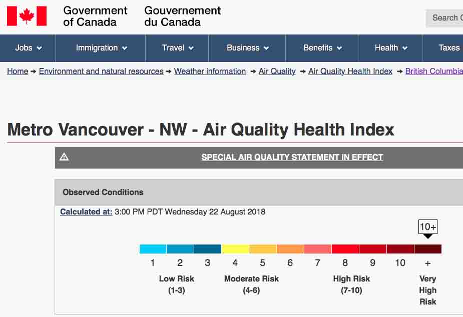
An air quality advisory was issued for Metro Vancouver and the Fraser Valley on Tuesday. Then the smoke from higher elevations descended that night. Wednesday morning, I walked into Ladner village through a haze that smelled of old fire. An uneasy disquiet stirred inside me. Then I realized it; the air wasn’t that easy to breathe. The AQI was over 150 and steadily climbing. By the time Sylvia and I left the café, the AQI would measure over 200 (considered “very unhealthy”).
According to Environment Canada meteorologist Lisa Coldwells, a broad dome of high pressure is sitting on top of the province, providing only slight winds even at high altitudes. “The smoke doesn’t have a chance to dissipate. It just comes up off the fire(s) and it’s just sort of gently moving towards Vancouver, the southern tip of Vancouver Island and the most populated areas,” she says. A temperature inversion is making the situation worse, effectively trapping the smoke.
Fine particulate matter, also known as PM2.5 (measured as particles at or smaller than 2.5 µm) is causing most of the haze and driving the health warnings. These particles pose the greatest health risk. Much smaller than the width of a human hair these particles can go deep into the lungs and bloodstream, resulting in oxidative stress and affecting the heart. Smoke will also carry coarse particulate matter, known as PM10 (particles that measure 10 µm to 2.5 µm). Coarse particles are of less concern, given they are more easily caught by our filtering systems (like nose hairs and phlegm) but can irritate your eyes, nose and throat. Concentrations of PM2.5 greater than 25 micrograms per cubic metre prompt health warnings. According to Chris Carlsten, UBC public health associate professor, these higher levels dysregulate the normal balance in the lungs, leading to inflammation that causes difficulty in breathing and wheezing.
The Air Quality Health Index (AQHI) was developed by Environment Canada, the BC Ministry of Environment and BC Ministry of Health, Metro Vancouver and the BC Lung Association to measure air quality on a scale. The index typically goes from 0 to 10 with 7-10 representing “high risk” conditions. Numbers higher than 10 are unusual and indicate a very high risk to health. The 0 to 10 index corresponds roughly to the Air Quality Index (AQI), which measures concentrations of particulate matter, sulfur dioxide, carbon monoxide, nitrogen dioxide and ozone and converts these to a number on a scale of 0 to 500.
As you can see, an AQI of over 100 is moderately polluted and considered unhealthy, particularly for sensitive groups such as people with asthma, respiratory issues, elderly or small children. Today, Ladner’s AQI rose steadily during the day until it was well over 200, considered very unhealthy.
According to Tiffany Crawford of the Vancouver Sun, the air quality in Vanderhoof—30 kilometres south of the more than 86,000-hectare Shovel Lake wildfire—measured over 600 on the AQI; more than double the level considered hazardous to health. The AQI in Houston measured 410 and in Burns Lake it was 408—all levels way beyond ‘hazardous’.
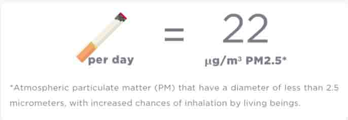
To give you an idea of how that feels, someone developed an app using Berkley Earth’s findings on the equivalence between air pollution and cigarette smoking. According to Berkley’s formula one cigarette smoked per day equals 22 µg/m3 of fine particulate matter.
The current air quality rating in Vancouver measured 10 today, which is like smoking 7.4 cigarettes. In Abbotsford in the Fraser Valley, that comes to 8.3 cigarettes. Further north in Fort St. John you’re smoking 11.8 cigarettes and in Prince George you’re smoking 16.7 cigarettes. By contrast, in Gwallior India—one of the most air-polluted places in the world—the equivalent daily cigarettes smoked is only 3.5.
Smoky sun over Ladner at 6 pm (photo by Nina Munteanu)
As the coffee machines ground and wheezed with the sweet aroma of coffee, Sylvia and I talked about an exciting project that involved ecology and empowerment. Of course, we talked about the wildfires too. How could we not? It was on everyone’s mind today. With such overt signs, who couldn’t think of them. It was the smoke. We saw it coil and loiter along the street corners. We smelled it. Breathed it in. Felt it inside us. The remains of so many trees that had burned to the ground. “The souls of trees,” as good friend Anne had blurted out. Their ashes and smoke had soared high into the atmosphere and now descended on us, kilometres away. I couldn’t help feeling a sadness. Not just for so many people in hardship. But for so much living tissue, burnt up in smoke.
Sylvia later told me that she didn’t make her next appointment in Vancouver. Feeling the effects of the smoke, she had decided to go home, where her HEPA filter awaited. Smart move, Sylvia.
Nina Munteanu is an ecologist, limnologist and internationally published author of award-nominated speculative novels, short stories and non-fiction. She is co-editor of Europa SF and currently teaches writing courses at George Brown College and the University of Toronto. Visit www.ninamunteanu.ca for the latest on her books.
For several years I’ve been returning from Toronto—where I teach at The University of Toronto and George Brown College—to Ladner, BC to spend my summers.
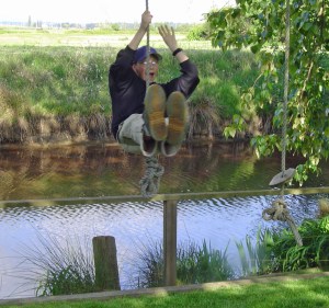
I cherish the time as a chance to see family and friends and to enjoy a different pace of life—one I enjoyed when I used to live and work here and where I brought up my family. We lived in a comfortable house on a quiet street and our back yard faced one of Ladner’s sloughs and beyond that a vast tract of farmland, most often scored with rows of potato plants. My son Kevin had grown up swimming in the slough and jumping off the rope swing his dad had constructed. Pilgrims from close and far came to use that swing and enjoy the murky waters of our back slough.
Kevin on the rope swing
Parties at our place always involved water and getting wet. We even had a fleet of kayaks and canoes that we took on paddling adventures through farmland and under highways, with the occasional siting of muskrat, carp, heron, or eagle. Coyotes whined and barked at night as bats dipped through the night air, foraging for food. My female cat poised for the hunt and sometimes brought in her “catch of the day.”
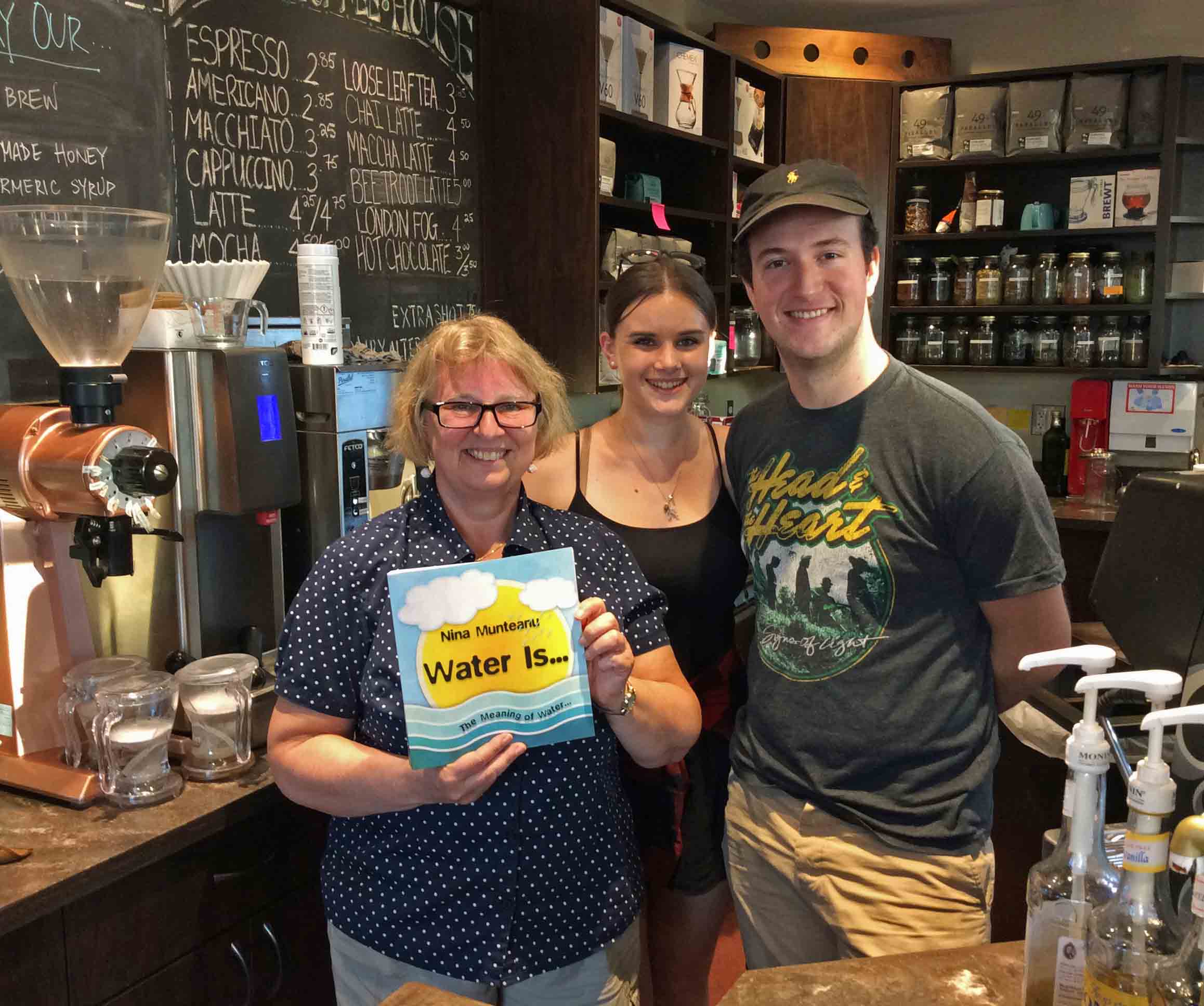
Cathleen and Nina at Stir
This summer, good friend and writer Cathleen Chance Vecchiato decided I should give a talk to my old community on Water Is… my recent bestselling book on water. With that, she immediately made it happen. The venue was already decided: the best café in Ladner, Stir Coffee House. I’d taken Cathleen there the previous year as part of a tour of the old farming and fishing village. Cathleen was charmed by the village atmosphere.
Stir Coffee House was happy to host a talk and Robert and Cathleen proceeded to plan it. Ian Jacques at The Delta Optimist wrote a wonderful piece on my journey, the talk and the book.
On the evening of August 16th a growing crowd of people, eager for more on this precious substance flowed into the café until there was hardly a seat left in the cozy venue. I recognized some locals as well as colleagues from my environmental consulting days in Vancouver. It was a good crowd.
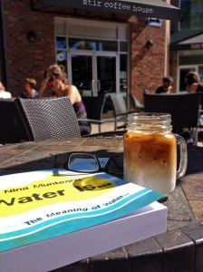
Water Is… snug against an iced latte
I shared the story of how I came to write this book—not a limnology book for non-scientists, as I thought I was going to write—but something that was more than science. Something that encompassed so much more about water: what it means to each of us and how we still don’t understand its many magical anomalous properties. I confided my discovery that the synchronicity of important moments in my life were all connected to water, which compelled the book to evolve into a study of “what water means to us.” Good friend Emmi Itäranta, author of Memory of Water, called Water Is… a biography of water.
Travelling the world has helped me realize that I was blessed with an abundance of water. I lived my entire life in a country of plentiful and healthy water. And for most of that time I didn’t even realize it. Canada holds one fifth of the world’s fresh water in lakes, rivers, and wetlands, as well as in our underground aquifers and glaciers. Canada’s wetlands, which cover more than 1.2 million square kilometres, makes Canada the largest wetland area in the world.
Nina with hosts Hope and Trevor
Perhaps it is no coincidence that Canada is steward of the world’s largest wetlands. Wetlands include marshes, swamps, fens, and bogs, all irreplaceable habitat for a huge diversity of nesting, feeding and staging waterfowl, reptiles, amphibians and mammals—many at risk. Wetlands provide a major filtration system, removing contaminants, improving water quality and renewing water’s vitality; wetlands serve as reservoirs, controlling and reducing flooding toward a more balanced hydrological cycle. Wetlands are a source of oxygen and water vapour, serving a vital role in our global atmospheric and climatic cycles. As ecotones— transitional areas—wetlands protect coasts from erosion and provide exceptional opportunity for boundary interaction and the emergence of vitality. Like a good metaphor, wetlands “recognize” and encompass similarities between dissimilarities. Wetlands powerfully connect. Canada’s strong multi-cultural policies and its open tolerance in embracing and celebrating diversity makes it the “wetland” of the world.
When I turn on the water tap in my house in Canada, it is pure drinking water. I don’t need to boil it or filter it or test it for impurities and toxins. I am confident that it will nourish and hydrate me like water should. I can bathe without restriction. I can play with it.
My water hasn’t changed; but I have. I do not take it for granted. I know that I am blessed.
I am home and I am so grateful.
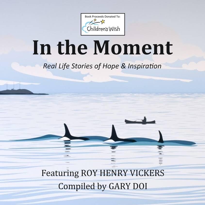
Part of this article is an excerpt from Nina Munteanu’s “Coming Home to Water” first published in “In the Moment” (A Hopeful Sign) edited by Gary Doi, September 2016; reprinted in “The Earth We Love” (Mississauga Writers) edited by Elizabeth Banfalvi, September 2018; and “The Literary Connection IV: Then and Now” (IOWI) edited by Cheryl Antao Xavier, upcoming 2018.
Nina Munteanu is an ecologist, limnologist and internationally published author of award-nominated speculative novels, short stories and non-fiction. She is co-editor of Europa SF and currently teaches writing courses at George Brown College and the University of Toronto. Visit www.ninamunteanu.ca for the latest on her books.


 In my novel “
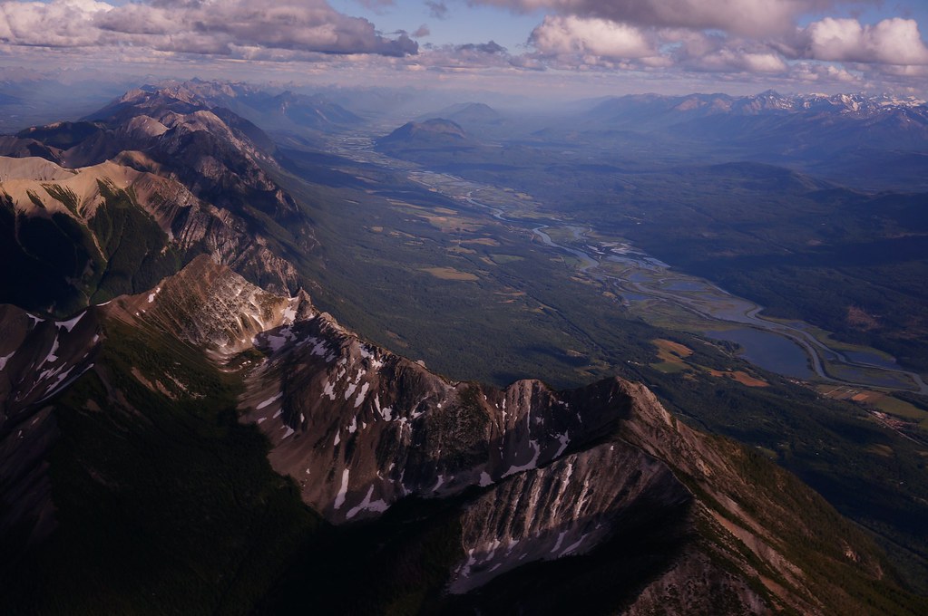


 Nina Munteanu is an ecologist, limnologist and internationally published author of award-nominated speculative novels, short stories and non-fiction. She is co-editor of Europa SF and currently teaches writing courses at George Brown College and the University of Toronto. Visit


 Part of this article is an excerpt from Nina Munteanu’s “Coming Home to Water” first published in “In the Moment” (A Hopeful Sign) edited by Gary Doi, September 2016; reprinted in “The Earth We Love” (Mississauga Writers) edited by Elizabeth Banfalvi, September 2018; and “The Literary Connection IV: Then and Now” (IOWI) edited by Cheryl Antao Xavier, upcoming 2018.